
File:FEB 11 2021 Updated CCG Regional Map.jpg

Size of this preview: 776 × 600 pixels. Other resolutions: 311 × 240 pixels | 621 × 480 pixels | 994 × 768 pixels | 1,280 × 989 pixels | 2,560 × 1,978 pixels | 3,300 × 2,550 pixels.
Original file (3,300 × 2,550 pixels, file size: 568 KB, MIME type: image/jpeg)
| This is a file from the Wikimedia Commons. Information from its description page there is shown below. Commons is a freely licensed media file repository. You can help. |
Summary
| Description |
English: Map showing the operating regions of the Canadian Coast Guard (left to right): Western region (British Columbia, Alberta, Saskatchewan, Manitoba, and Yukon, minus the Yukon North Slope), Arctic region (Yukon, Northwest Territories, Nunavut, Hudson Bay and James Bay), Central region (Ontario and Quebec) and Atlantic region (Newfoundland and Labrador, Nova Scotia, New Brunswick and Prince Edward Island). |
| Date | |
| Source | Own work |
| Author | Hscime |
Licensing
I, the copyright holder of this work, hereby publish it under the following license:
This file is licensed under the Creative Commons Attribution-Share Alike 4.0 International license.
- You are free:
- to share – to copy, distribute and transmit the work
- to remix – to adapt the work
- Under the following conditions:
- attribution – You must give appropriate credit, provide a link to the license, and indicate if changes were made. You may do so in any reasonable manner, but not in any way that suggests the licensor endorses you or your use.
- share alike – If you remix, transform, or build upon the material, you must distribute your contributions under the same or compatible license as the original.
File history
Click on a date/time to view the file as it appeared at that time.
| Date/Time | Thumbnail | Dimensions | User | Comment | |
|---|---|---|---|---|---|
| current | 20:48, 20 November 2023 | 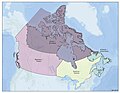 | 3,300 × 2,550 (568 KB) | Hscime | Uploaded while editing "List of Canadian Coast Guard bases and stations" on en.wikipedia.org |
File usage
The following pages on the English Wikipedia use this file (pages on other projects are not listed):
Global file usage
The following other wikis use this file:
- Usage on de.wikipedia.org
- Usage on ja.wikipedia.org