
Portal:Interstate Highway System
Introduction
The Dwight D. Eisenhower National System of Interstate and Defense Highways, commonly known as the Interstate Highway System, or the Eisenhower Interstate System, is a network of controlled-access highways that forms part of the National Highway System in the United States. The system extends throughout the contiguous United States and has routes in Hawaii, Alaska, and Puerto Rico.
In the 20th century, the United States Congress began funding roadways through the Federal Aid Road Act of 1916, and started an effort to construct a national road grid with the passage of the Federal Aid Highway Act of 1921. In 1926, the United States Numbered Highway System was established, creating the first national road numbering system for cross-country travel. The roads were state-funded and maintained, and there were few national standards for road design. United States Numbered Highways ranged from two-lane country roads to multi-lane freeways. After Dwight D. Eisenhower became president in 1953, his administration developed a proposal for an interstate highway system, eventually resulting in the enactment of the Federal-Aid Highway Act of 1956. (Full article...)
Selected general articles
-
 Interstate 86 (I-86) is an Interstate Highway that extends for 223.39 miles (359.51 km) through northwestern Pennsylvania and the Southern Tier region of New York, in the United States. The highway has two segments: the longer of the two begins at an interchange with I-90 east of Erie, Pennsylvania, and ends just beyond the Chemung-Tioga county line at the Pennsylvania border, while the second extends from I-81 east of Binghamton to New York State Route 79 (NY 79) in Windsor. When projects to upgrade the existing NY 17 to Interstate Highway standards are completed, I-86 will extend from I-90 near Erie to the New York State Thruway (I-87) in Woodbury. The portion in Erie County, Pennsylvania, is known as the Hopkins-Bowser Highway and is signed as such at each end. In New York, the current and future alignment of I-86 is known as the Southern Tier Expressway west of I-81 in Binghamton and the Quickway east of I-81.
I-86 travels 6.99 miles (11.25 km) in Pennsylvania and 216.4 miles (348.26 km) in New York. Except for a section of about 1.5 miles (2.4 km) that dips into Pennsylvania at exit 60 near the New York village of Waverly and the Pennsylvania borough of South Waverly, the rest of I-86 will be in New York. The section of NY 17 through South Waverly is maintained by the New York State Department of Transportation (NYSDOT), however. The Southern Tier Expressway section of I-86 and NY 17 comprises Corridor T of the Appalachian Development Highway System. I-86 connects to US Route 219 (US 219) in Salamanca, Seneca Nation; I-390 near Avoca and I-99/US 15 just west of Corning. (Full article...) -
Interstate 84 (I-84) is an east–west Interstate Highway across the state of Connecticut through Danbury, Waterbury, Hartford, and Union. (Full article...)
-
Interstate 77 (I-77) is a north–south Interstate Highway in the Eastern United States. It traverses diverse terrain, from the mountainous state of West Virginia to the rolling farmlands of North Carolina and Ohio. It largely supplants the old U.S. Route 21 (US 21) between Cleveland, Ohio, and Columbia, South Carolina, as an important north–south corridor through the middle Appalachian Mountains. The southern terminus of I-77 is in Cayce, South Carolina, in Lexington County at the junction with I-26. The northern terminus is in Cleveland at the junction with I-90. Other major cities that I-77 connects to include Columbia, South Carolina; Charlotte, North Carolina; Charleston, West Virginia; and Akron, Ohio. The East River Mountain Tunnel, connecting Virginia and West Virginia, is one of only two instances in the U.S. where a mountain road tunnel crosses a state line. The other is the Cumberland Gap Tunnel, connecting Tennessee and Kentucky. I-77 is a snowbird route to the Southern U.S. for those traveling from the Great Lakes region. (Full article...)
-
There are 70 primary Interstate Highways in the Interstate Highway System, a network of freeways in the United States. These primary highways are assigned one- or two-digit route numbers, whereas their associated auxiliary Interstate Highways receive three-digit route numbers. Typically, odd-numbered Interstates run south–north, with lower numbers in the west and higher numbers in the east; even-numbered Interstates run west–east, with lower numbers in the south and higher numbers in the north. Route numbers divisible by 5 usually represent major coast-to-coast or border-to-border routes (ex. I-10 connects Santa Monica, California to Jacksonville, Florida, extending between the Pacific and Atlantic oceans). Auxiliary highways have an added digit prefixing the number of the parent highway.
Five route numbers are duplicated in the system; the corresponding highways are in different regions, reducing potential confusion. In addition to primary highways in the contiguous United States, there are signed Interstates in Hawaii and unsigned Interstates in Alaska and Puerto Rico. (Full article...) -
Interstate 82 (I-82) is an Interstate Highway in the Pacific Northwest region of the United States that travels through parts of Washington and Oregon. It runs 144 miles (232 km) from its northwestern terminus at I-90 in Ellensburg, Washington, to its southeastern terminus at I-84 in Hermiston, Oregon. The highway passes through Yakima and the Tri-Cities, and is also part of the link between Seattle and Salt Lake City, Utah. I-82 travels concurrently with U.S. Route 97 (US 97) between Ellensburg and Union Gap; US 12 from Yakima to the Tri-Cities; and US 395 from Kennewick to Umatilla, Oregon.
I-82 primarily serves the Yakima Valley agricultural region, following the Yakima and Columbia rivers southeastward to the Tri-Cities. The highway enters the valley from the north by crossing the Manastash Ridge, which separates Yakima from the Kittitas Valley. I-82 bypasses the Tri-Cities by traveling southwest around Richland and Kennewick and then turns south to cross the Columbia River on the Umatilla Bridge. Its only auxiliary route, I-182, connects the highway to Richland and Pasco in the Tri-Cities. (Full article...) -
Interstate 76 (I-76) is an east–west Interstate Highway in the Western United States that runs from I-70 in Arvada, Colorado – near Denver – to an interchange with I-80 near Big Springs, Nebraska. The highway measures 187.29 miles (301.41 km) long, mostly situated in Colorado but approximately three miles (4.8 km) of which is in Nebraska. Along the route, the highway runs concurrent with US Route 6 (US 6), US 85 in the Denver metropolitan area, and US 34 from Wiggins to Fort Morgan. It has no auxiliary Interstates, but it has two business routes that are located in northeastern Colorado. This route is not connected with the other I-76 that spans from Ohio to New Jersey.
The section of I-76 from its western terminus at I-70 to the SH 71 interchange near Brush, Colorado is designated as part of the Heartland Expressway, a planned series of multi-lane highways connecting Denver and Rapid City, South Dakota. (Full article...) -
Interstate 57 (I-57) is a north–south Interstate Highway in Missouri and Illinois that parallels the old Illinois Central Railroad for much of its route. It runs from Sikeston, Missouri, at I-55 to Chicago, Illinois, at I-94. I-57 essentially serves as a shortcut route for travelers headed between the Southern U.S. (Memphis, New Orleans, etc.) and Chicago, bypassing St. Louis, Missouri, and Springfield, Illinois. Between the junction of I-55 and I-57 in Sikeston and the junction of I-55 and I-90/I-94 in Chicago, I-55 travels for 436 miles (702 km), while the combination of I-57 and I-94 is only 396 miles (637 km) long between the same two points. In fact, both the control cities on the overhead signs and the destination mileage signs reference Memphis along southbound I-57, even as far north as its northern origin at I-94 in Chicago. Likewise, at its southern end, Chicago is the control city listed for I-57 on signs on northbound I-55 south of Sikeston, even though I-55 also goes to Chicago. A southward extension of I-57 from its current southern terminus to Little Rock, Arkansas, is currently in various stages of development. (Full article...)
-
Interstate 14 (I-14), also known as the 14th Amendment Highway, the Gulf Coast Strategic Highway, and the Central Texas Corridor, is an Interstate Highway that is currently located entirely in Central Texas, following US Highway 190 (US 190). The portion of the route that has been constructed and signed to date, the Central Texas Corridor along US 190 west of I-35 was officially designated as I-14 by the Fixing America's Surface Transportation Act (FAST Act), signed by President Barack Obama on December 14, 2015.
The proposal for the "14th Amendment Highway" has its origins in the 2005 transportation bill, the Safe, Accountable, Flexible, Efficient Transportation Equity Act: A Legacy for Users (SAFETEA-LU). The route was initially planned to have a western terminus at Natchez, Mississippi (later from I-49 near Alexandria, Louisiana), extending east through Louisiana, Mississippi, and Alabama, before ending at Augusta, Georgia, or North Augusta, South Carolina. Advocates of the Gulf Coast Strategic Highway subsequently proposed extending I-14 to I-10 near Fort Stockton and the junction of US 277 and I-10 near Sonora, Texas. The study and planning of I-14 has continued because of support and interest from both Congress and the associated state highway departments. The I-14 corridor, if ultimately constructed, would provide a national strategic link to numerous major military bases and major Gulf and Atlantic coasts ports used for overseas deployments in six states from Texas to South Carolina. (Full article...) -
Interstate 86 (I-86) is an east–west intrastate Interstate Highway located entirely within the state of Idaho. It runs approximately 63 miles (101 km) from an intersection with I-84 east of Declo in rural Cassia County, to an intersection with I-15 in Chubbuck, just north of Pocatello. The highway is part of the main route from Boise and Twin Falls to Idaho Falls and the upper Snake River region.
I-86 runs through a sparsely populated region along the south side of the Snake River and is mostly concurrent with US Highway 30 (US-30), which it replaced in the 1970s. It passes through American Falls at its midpoint and has a business route that serves the city center. The highway also serves Minidoka National Wildlife Refuge, Massacre Rocks State Park, the Fort Hall Indian Reservation, and Pocatello Regional Airport. (Full article...) -
Interstate 97 (I-97) is a north-south Interstate Highway in the eastern United States. It runs entirely within Anne Arundel County, Maryland, for 17.62 miles (28.36 km) from U.S. Route 50/U.S. Route 301 (US 50/US 301) in Parole near Annapolis north to I-695 and I-895B in Brooklyn Park near Baltimore. The interstate is the primary highway between Baltimore and Annapolis. I‑97 connects Annapolis with Baltimore/Washington International Airport and links the northern Anne Arundel County communities of Crownsville, Millersville, Severna Park, Glen Burnie, and Ferndale. It is the second shortest primary Interstate Highway after I-87 in North Carolina.
I-97 was constructed along the corridor of Maryland Route 3 (MD 3) between Millersville and Ferndale and MD 178 between Parole and Millersville. From Millersville to south of Glen Burnie, the interstate closely follows the former course of MD 3, which was built in the late 1910s and early 1920s and expanded to a divided highway in the late 1950s. North of there, the highway follows the Glen Burnie Bypass, a freeway built in the mid-1950s. The segment of I-97 from Millersville to Crownsville originated as a two-lane portion of MD 32 in the early 1970s. The interstate was introduced in 1979 after the state of Maryland successfully obtained interstate mileage for a Baltimore–Annapolis freeway from the federal government. The state decided to build the highway along I-97's current corridor rather than along the MD 2 corridor, which has partial freeway access via MD 10. (Full article...) -
Interstate 26 (I-26) is a main route of the Interstate Highway System in the Southeastern United States. Nominally east–west, as indicated by its even number, I-26 runs from the junction of US Route 11W (US 11W) and US 23 in Kingsport, Tennessee, generally southeastward to US 17 in Charleston, South Carolina. The portion from Mars Hill, North Carolina, east (compass south) to I-240 in Asheville, North Carolina, has signs indicating FUTURE I-26, because the highway does not yet meet all of the Interstate Highway standards.
Northward from Kingsport, US 23 continues to Portsmouth, Ohio, as Corridor B of the Appalachian Development Highway System, and beyond to Columbus, Ohio, as Corridor C. In conjunction with the Columbus–Toledo corridor in Ohio formed by I-75, US 23, and State Route 15 (SR 15), I-26 forms part of a mostly high-speed four-or-more-lane highway from the Great Lakes to the Atlantic Coast at Charleston, South Carolina. (Full article...) -
The Interstate Highways in Alaska are all owned and maintained by the US state of Alaska. The Alaska Department of Transportation & Public Facilities (DOT&PF) is responsible for the maintenance and operations of the Interstate Highways. The Interstate Highway System in Alaska comprises four highways that cover 1,082.22 miles (1,741.66 km). The longest of these is Interstate A-1 (A-1), at 408.23 miles (656.98 km) long, while the shortest route is A-3, at 148.12 miles (238.38 km) long. All Interstates in Alaska are unsigned and are not generally referred to by their highway numbers.
Interstates in Alaska follow the numbering system Interstate A-n, where n represents the number of the Interstate. This follows the similar numbering systems for Hawaii and Puerto Rico. The Interstate Highway System was expanded to Alaska in 1976, by the Federal-Aid Highway Act of 1976, which defined the system for Interstates in Alaska and Puerto Rico under . (Full article...) -

In the United States, future Interstate Highways include proposals to establish new mainline (one- and two-digit) routes to the Interstate Highway System. Excluded from this article are auxiliary Interstate Highways (designated by three-digit numbers) in varying stages of planning and construction, and the planned expansion of existing primary Interstate Highways. (Full article...) -
Interstate 69 (I-69) is an Interstate Highway in the United States currently consisting of 10 unconnected segments with an original continuous segment from Indianapolis, Indiana, northeast to the Canadian border in Port Huron, Michigan, at 355.8 miles (572.6 km). The remaining separated segments are variously completed and posted or not posted sections of an extension southwest to the Mexican border in Texas. Of this extension—nicknamed the NAFTA Superhighway because it would help trade with Canada and Mexico spurred by the North American Free Trade Agreement (NAFTA)—seven pieces in Laredo, Texas; Pharr, Texas; Brownsville, Texas; Corpus Christi, Texas; Houston, Texas; northwestern Mississippi; and Memphis, Tennessee, have been built or upgraded and signposted as I-69. Indiana is currently working on a fifth segment that will extend I-69 through the entire state while a sixth segment of I-69 through Kentucky utilizing that state's existing parkway system and a section of I-24 was established by federal legislation in 2008 with several more parkway segments being upgraded since then. This brings the total length to about 880 miles (1,420 km).
The proposed extension evolved from the combination of Corridors 18 and 20 of the National Highway System as designated in the Intermodal Surface Transportation Efficiency Act of 1991 (ISTEA), but the federally recognized corridor also includes connecting and existing infrastructure, including I-94 between Chicago, Illinois, and Port Huron, Michigan, and several spurs from I-69. Among these proposed spurs are an extension of I-530 from Pine Bluff, Arkansas; an upgrade of U.S. Route 59 (US 59) from Texarkana, Texas being designated as Interstate 369; and a split in southern Texas (I-69E, I-69C, I-69W) to serve three border crossings at Brownsville, Pharr, and Laredo. (Full article...) -
Interstate 84 (I-84) is an Interstate Highway in the northwestern United States. The highway runs from Portland, Oregon, to a junction with I-80 near Echo, Utah. The highway serves and connects Portland, Boise, and Ogden, Utah. With connections to other highways, I-84 connects these cities to points east and also serves as part of a corridor between Seattle and Salt Lake City. The sections running through Oregon and Idaho are also known as the Vietnam Veterans Memorial Highway.
The highway originally served as a fork of I-80 to serve the Pacific Northwest, and was originally numbered Interstate 80N. It was generally built along the corridor of U.S. Route 30 (US 30) and US 30S, which themselves largely followed the Oregon Trail; the US 30S designation was decommissioned in the 1970s after the freeway replacement was mostly complete. The highway was signed with the I-84 designation in 1980, when a 1977 change in guidelines took effect that discouraged highway numbers with directional suffixes. The renumbering resulted in two highways being numbered I-84, with the other located in the Northeastern United States. (Full article...) -
Interstate 22 (I-22) is a 202.22-mile-long (325.44 km) Interstate Highway in the US states of Mississippi and Alabama, connecting I-269 near Byhalia, Mississippi, to I-65 near Birmingham, Alabama. I-22 is also Corridor X of the Appalachian Development Highway System (ADHS). Designated in 2012, I-22 follows the route of older U.S. Route 78 (US 78) and is concurrent with the route for all but its eastern most 11 miles (18 km). The freeway mainly spans rural areas and passes numerous small towns along its route, including Fulton, Tupelo, New Albany, and Holly Springs in Mississippi and Jasper, Winfield, and Hamilton in Alabama.
I-22 was upgraded to Interstate Highway standards to close a gap in the Interstate Highway System, allowing for more direct connections between cities in the southeast with cities in the central part of the country. I-22 indirectly connects I-240, I-40, I-55, and I-69 in the Memphis metropolitan area via US 78 and I-269, and indirectly connects with I-459, I-20, and I-59 in the Birmingham metropolitan area via I-65. (Full article...) -
Interstate 66 (I-66) is a 76.32 mile east–west Interstate Highway in the eastern United States. The highway runs from an interchange with I-81 near Middletown, Virginia, on its western end to an interchange with U.S. Route 29 (US 29) in Washington, D.C., at the eastern terminus. Much of the route parallels US 29 or State Route 55 (SR 55) in Virginia. I-66 has no physical or historical connection to US 66, which was located in a different region of the United States.
The E Street Expressway is a spur from I-66 into the Foggy Bottom neighborhood of Washington, D.C. (Full article...) -
Interstate 89 (I-89) is an Interstate Highway in the New England region of the United States traveling from Bow, New Hampshire, to the Canada–United States border between Highgate Springs, Vermont, and Saint-Armand, Quebec. As with all odd-numbered primary Interstates, I-89 is signed as a north–south highway. However, it follows a primarily northwest-to-southeast path. The route forms a major part of the main connection between the cities of Montreal and Boston. In Quebec, the route continues as Route 133. The eventual completion of Autoroute 35 will lead to a nonstop limited-access highway route between Boston and Montreal, following I-93 south from I-89's terminus. The largest cities directly served by I-89 are Concord, the state capital of New Hampshire; Montpelier, the state capital of Vermont; and Burlington, Vermont. I-89 is one of three main Interstate highways whose route is located entirely within New England, along with I-91 and I-93 (both of which also have their northernmost pavement in Vermont).
I-89 connects smaller cities and rural areas within New Hampshire and Vermont, and maintains two lanes of traffic in each direction throughout the route. Unlike its neighboring Interstates, it does not intersect any even-numbered Interstates along its route. It does, however, parallel (and intersect multiple times with) portions of three US Routes: US Route 4 (US 4) from Enfield, New Hampshire, to Hartford, Vermont; US 2 from Montpelier to Colchester, Vermont; and US 7 from Burlington to the Canadian border. US 7 and US 2 overlap each other between Burlington and Colchester. (Full article...) -
Interstate H-3 (H-3) is an Interstate Highway located entirely within the US state of Hawaii on the island of Oʻahu. H-3 is also known as the John A. Burns Freeway, after the second governor of Hawaii. It crosses the Koʻolau Range along several viaducts and through the 5,165-foot-long (1,574 m) Tetsuo Harano Tunnels as well as the much smaller Hospital Rock Tunnels.
Despite the number, signage is that of an east–west highway. Its western terminus is at an interchange with H-1 at Halawa near Pearl Harbor. Its eastern end is at the main gate of Marine Corps Base Hawaii (MCBH). This route satisfies the national defense purpose of connecting MCBH with the US Navy port at Pearl Harbor off H-1. (Full article...) -
The Interstate Highways in Alaska are all owned and maintained by the US state of Alaska. The Alaska Department of Transportation & Public Facilities (DOT&PF) is responsible for the maintenance and operations of the Interstate Highways. The Interstate Highway System in Alaska comprises four highways that cover 1,082.22 miles (1,741.66 km). The longest of these is Interstate A-1 (A-1), at 408.23 miles (656.98 km) long, while the shortest route is A-3, at 148.12 miles (238.38 km) long. All Interstates in Alaska are unsigned and are not generally referred to by their highway numbers.
Interstates in Alaska follow the numbering system Interstate A-n, where n represents the number of the Interstate. This follows the similar numbering systems for Hawaii and Puerto Rico. The Interstate Highway System was expanded to Alaska in 1976, by the Federal-Aid Highway Act of 1976, which defined the system for Interstates in Alaska and Puerto Rico under . (Full article...) -

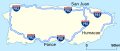
The Parks Highway near Hurricane
The George Parks Highway (numbered Interstate A-4 and signed Alaska Route 3), usually called simply the Parks Highway, runs 323 miles (520 km) from the Glenn Highway 35 miles (56 km) north of Anchorage to Fairbanks in the Alaska Interior. The highway, originally known as the Anchorage-Fairbanks Highway, was completed in 1971, and given its current name in 1975.
The highway, which mostly parallels the Alaska Railroad, is one of the most important roads in Alaska. It is the main route between Anchorage and Fairbanks (Alaska's two largest metropolitan areas), the principal access to Denali National Park and Preserve and Denali State Park, and the main highway in the Matanuska-Susitna Valley. The route's Interstate designation is not signed; rather, its entire length is signed as Alaska Route 3. (Full article...) -
Interstate H-2 (H-2, named the Veterans Memorial Freeway) is an intrastate Interstate Highway located on the island of Oʻahu in the U.S. state of Hawaii. The north–south freeway connects H-1 in Pearl City to Mililani and Wahiawa, where it terminates at Route 99 near Schofield Barracks.
The Interstate System was expanded to Hawaii in 1960 along several corridors, with H-2 assigned to the north–south connection between the Honolulu area and Wahiawa. Construction began in 1971, and the first section opened to traffic on October 3, 1974. The rest of H-2 was completed on February 21, 1977. (Full article...) -
Interstate 4 (I-4) is an Interstate Highway located entirely within the US state of Florida, maintained by the Florida Department of Transportation (FDOT). Spanning 132.30 miles (212.92 km) along a generally southwest–northeast axis, I-4 is entirely concurrent with State Road 400 (SR 400). In the west, I-4 begins at an interchange with I-275 in Tampa. I-4 intersects with several major expressways as it traverses Central Florida, including US Highway 41 (US 41) in Tampa; US 301 near Riverview; I-75 near Brandon; US 98 in Lakeland; US 27 in unincorporated Davenport; US 192 in Celebration; Florida's Turnpike in Orlando; and US 17 and US 92 in multiple junctions. In the east, I-4 ends at an interchange with I-95 in Daytona Beach, while SR 400 continues for roughly another four miles (6.4 km) and ends at an intersection with US 1 on the city line of Daytona Beach and South Daytona.
Construction on I-4 began in 1958; the first segment opened in 1959, and the entire highway was completed in 1965. The "I-4 Ultimate" project oversaw the construction of variable-toll express lanes and numerous redevelopments through the 21-mile (34 km) stretch of highway extending from Kirkman Road (SR 435; exit 75) in Orlando to SR 434 (exit 94) in Longwood. The project broke ground in 2015, and the express lanes opened to traffic on February 26, 2022. Previously, the median of I-4 between Tampa and Orlando was the planned route of a now-canceled high-speed rail line; however, Brightline, an inter-city rail route, plans to use the I-4 right-of-way for their expansion of service to Tampa. From a political standpoint, the "I-4 corridor" is a strategic region given the large number of undecided voters in a large swing state. (Full article...) -
Interstate 95 (I-95) is the main north–south Interstate Highway on the East Coast of the United States, running from U.S. Route 1 (US 1) in Miami, Florida, north to the Houlton–Woodstock Border Crossing between Maine and the Canadian province of New Brunswick. The highway largely parallels the Atlantic coast and US 1, except for the portion between Savannah, Georgia, and Washington, D.C., and the portion between Portland and Houlton in Maine, both of which follow a more direct inland route.
I-95 serves as the principal road link between the major cities of the Eastern Seaboard. Major metropolitan areas along its route include Miami, Jacksonville, Savannah, and Richmond in the Southeast; Washington, Baltimore, Wilmington–Philadelphia, Newark, and New York City in the Mid-Atlantic; and New Haven, Providence, Boston, and Portland in New England. The Charleston, Wilmington, and Norfolk–Virginia Beach metropolitan areas, the three major coastal metros bypassed by the highway's inland portion, are connected to I-95 by I-26, I-40, and I-64, respectively. (Full article...) -
Interstate 90 (I-90) is an east–west transcontinental freeway and the longest Interstate Highway in the United States at 3,021 miles (4,862 km). It begins in Seattle, Washington, and travels through the Pacific Northwest, Mountain West, Great Plains, Midwest, and the Northeast, ending in Boston, Massachusetts. The highway serves 13 states and has 15 auxiliary routes, primarily in major cities such as Chicago, Cleveland, Buffalo, and Rochester.
I-90 begins at Washington State Route 519 in Seattle and crosses the Cascade Range in Washington and the Rocky Mountains in Montana. It then traverses the northern Great Plains and travels southeast through Wisconsin and the Chicago area by following the southern shore of Lake Michigan. The freeway continues across Indiana and follows the shore of Lake Erie through Ohio and Pennsylvania to Buffalo. I-90 travels across New York by roughly following the historic Erie Canal and traverses Massachusetts, reaching its eastern terminus at Massachusetts Route 1A near Logan International Airport in Boston. (Full article...)


Did you know...
- ... that Interstate 182 was created as a compromise for the states of Washington and Oregon?
- ... that Interstate 81 in Tennessee was the site of a carjacking that culminated in the Lillelid murders in 1997?
- ... that Interstate 90 is the longest freeway in the United States, at 3,020 miles (4,860 km)?
- ... that the completion of Interstate 205 in Oregon was delayed to mitigate air and noise pollution for a jail that closed a few months later?
- ... that a section of Interstate 65 in Tennessee was the first part of the Interstate Highway System to open in the state?
- ... that reconstruction of Nebraska's Interstate 180 was disrupted by the discovery of nesting migratory birds?
Need help?
Do you have a question about Interstate Highway System that you can't find the answer to?
Consider asking it at the Wikipedia reference desk.
Selected images
-
 Commemorative sign introduced in 1993. The system was established during Dwight D. Eisenhower's presidency, and the five stars commemorate his rank as General of the Army during World War II. (from Interstate Highway System)
 -
 Several Interstate shield design proposals submitted by the Texas Highway Department
 -
 FDR's hand-drawn map from 1938 (from Interstate Highway System)
 -

-
 A view of I-75 in Atlanta, Georgia, featuring HOV lanes running alongside the median (from Interstate Highway System)
 -

-
 I‑787 in Watervliet, New York, showing the exit 8 diamond interchange (from Interstate Highway System)
 -
 Map of routes in Puerto Rico that receive funding from the Interstate program, but are not signed as Interstate Highways (from Interstate Highway System)
 -
 Map of routes in Alaska that receive funding from the Interstate program, but are not signed as Interstate Highways (from Interstate Highway System)
 -
 Odd numbers run north–south with numbers increasing from west to east, while even numbers run east–west with numbers increasing from south to north. (from Interstate Highway System)
 -

-
 1955 map: The planned status of US Highways in 1965, as a result of the developing Interstate Highway System (from Interstate Highway System)
 -
 The fervor of urban renewal led to the routing of Interstate 81 through the middle of Syracuse's 15th Ward in the 1960s. The viaduct is now slated for demolition. (from Interstate Highway System)
 -
 Examples of the auxiliary Interstate Highway numbering system. An odd hundreds digit means the route connects at only one end to the rest of the interstate system, known as a "spur route" (see I-310 and I-510 in image). An even hundreds digit means the route connects at both ends, which could be a bypass route (which has two termini) (see I-210 and I-810 in image) or a radial route (known also as a beltway, beltline, or circumferential route) (see I-610 in image). (from Interstate Highway System)
 -
 An I-76 trailblazer along the Pennsylvania Turnpike with the black-on-yellow "Toll" sign (from Interstate Highway System)
 -
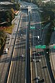
 Motor vehicles on I-95 in Miami (from Interstate Highway System)
 -
 The Pershing Map (from Interstate Highway System)
 -
 A rural stretch of I-5 in California; two lanes in each direction are separated by a large grassy median and cross-traffic is limited to grade separations such as this overpass. (from Interstate Highway System)


_in_Columbia,_Howard_County,_Maryland.jpg)
.jpg)


_just_west_of_Exit_320_in_Charlestown_Township,_Chester_County,_Pennsylvania.jpg)


Subcategories

- Select [►] to view subcategories
Topics
| Signed | |
|---|---|
| Unsigned | |
| Lists | |
| Other | |
Routes in italics are no longer a part of the system. Major Interstates are highlighted. | |
Associated Wikimedia
The following Wikimedia Foundation sister projects provide more on this subject:
-
 Commons
Free media repository -
 Wikibooks
Free textbooks and manuals -
 Wikidata
Free knowledge base -
 Wikinews
Free-content news -
 Wikiquote
Collection of quotations -
 Wikisource
Free-content library -
 Wikiversity
Free learning tools -
 Wiktionary
Dictionary and thesaurus