
Flores
 Topography of Flores | |
 | |
| Geography | |
|---|---|
| Location | Southeast Asia |
| Coordinates | 8°40′29″S 121°23′04″E / 8.67472°S 121.38444°E |
| Archipelago | Lesser Sunda Islands |
| Area | 14,731.67 km2 (5,687.93 sq mi)[1] |
| Area rank | 60th |
| Length | 354 km (220 mi) |
| Width | 66 km (41 mi) |
| Highest elevation | 2,370 m (7780 ft) |
| Highest point | Poco Mandasawu |
| Administration | |
Indonesia | |
| Province | East Nusa Tenggara |
| Largest settlement | Maumere (pop. 91,550) |
| Demographics | |
| Population | 1,962,405 (mid 2023) |
| Pop. density | 133.2/km2 (345/sq mi) |
Flores is one of the Lesser Sunda Islands, a group of islands in the eastern half of Indonesia. Administratively, it forms the largest island in the East Nusa Tenggara Province. Including Komodo and Rinca islands off its west coast (but excluding the Solor Archipelago to the east of Flores), the land area is 14,731.67 km2, and the population was 1,878,875 in the 2020 Census (including various offshore islands); the official estimate as of mid-2023 was 1,962,405.[2] The largest towns are Maumere and Ende. The name Flores is of Portuguese origin, meaning "Flowers".
Flores is located east of Sumbawa and the Komodo Islands, and west of the Solor Islands and the Alor Archipelago. To the southeast is Timor. To the south, across the Sumba Strait, is Sumba Island, and to the north, beyond the Flores Sea, is Sulawesi.
Among all islands containing Indonesian territory, Flores is the 10th most populous after Java, Sumatra, Borneo (Kalimantan), Sulawesi, New Guinea, Bali, Madura, Lombok, and Timor and also the 10th biggest island of Indonesia.
Until the arrival of modern humans, Flores was inhabited by Homo floresiensis, a small archaic human.
Etymology[edit]
Unlike most islands in the Indonesian archipelago, the modern name Flores was given by the Portuguese. According to Sareng Orin Bao (1969),[3] the oral tradition of the Sika region gave to the island the originel name of Nusa Nipa,[a] meaning ‘Dragon island’[5] or Snake island. (Nipa nai means "ascending snakes"; kaju nipa nai is the name of an unidentified tree with a bark resembling snake skin, but it can also mean "driftwood", or any sort of wood washed up in a flood.[6]) Forth says that “‘Nusa Nipa’ is a designation which at present is widely accepted on Flores as the indigenous name for the entire island. In spite of the argument of Sareng Orin Bao (1969) who adduces a variety of evidence favoring this interpretation, it remains uncertain whether this was in a fact a traditional usage, or at any rate on that was known throughout Flores.”[7] The names Tandjoeng Bunga or Tanjung Bunga[8] and Pulau Bunga[9] are also mentioned.
Then the island was discovered by Portugese explorer Diogo de Teive and his son in 1452,[10] and was then given the name of Sao Tomas or Santa lria.[11] The eastern part of the island, originally called Kopondai, was called Cabo das Flores (Cape of Flowers) because of the flowering flamboyants trees found there.[12] That name remained.
History[edit]
Prehistory[edit]
Before the arrival of modern humans, Flores was occupied by Homo floresiensis, a small archaic human.[13] The ancestors of Homo floresiensis arrived on the island between 1.3 and 1 million years ago.[14]
Remains of nine individuals have been found,[15][16] and the dominant consensus is that these remains do represent a distinct species due to anatomical differences from modern humans.[17] The most recent evidence shows that Homo floresiensis likely became extinct 50,000 years ago, around the time of modern human arrival to the archipelago.[18]
-
 H. floresiensis skull, Cantonal Museum of Geology, Switzerland
 -
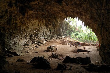 Liang Bua Cave, where the specimens were discovered


Modern history[edit]

Flores was most likely first inhabited by Melanesians at least since 30,000 BC.
Portuguese traders and missionaries came to Flores in the 16th century, mainly to Larantuka and Sikka. Their influence is still discernible in Sikka's language, culture, and religion. The first Portuguese visit took place in 1511, through the expedition of António de Abreu and his vice-captain Francisco Serrão, en route through the Sunda islands.
The Dominican order played an important role on this island, as well as on the neighbouring islands of Timor and Solor. When the Dutch attacked the fortress of Solor in 1613, the population of the fort, led by the Dominicans, moved to the harbor town of Larantuka on the eastern coast of Flores. This population was mixed, of Portuguese and local islander descent and Larantuqueiros, Topasses, or, as the Dutch knew them, the 'Black Portuguese' (Zwarte Portugezen).
The Larantuqueiros or Topasses became the dominant sandalwood trading people of the region for the next 200 years. This group was observed by William Dampier, an English privateer visiting the Island in 1699:
These [the Topasses] have no Forts, but depend on their Alliance with the Natives: And indeed they are already so mixt, that it is hard to distinguish whether they are Portuguese or Indians. Their Language is Portuguese; and the religion they have, is Romish. They seem in Words to acknowledge the King of Portugal for their Sovereign yet they will not accept any Officers sent by him. They speak indifferently the Malayan and their native Languages, as well as Portuguese.[19]
In the western part of Flores, the Manggarai came under the control of the Sultanate of Bima, in eastern Sumbawa. The Dutch effectively established their administration over western Flores in 1907. In 1929, the Bimanese sultanate ceded any control over Manggarai.
In 1846, the Dutch and Portuguese initiated negotiations towards delimiting the territories but these negotiations led nowhere. In 1851 Lima Lopes, the new governor of Timor, Solor and Flores, agreed to sell eastern Flores and the nearby islands to the Dutch in return for a payment of 200,000 Florins to support his impoverished administration. Lima Lopes did so without the consent of Lisbon and was dismissed in disgrace, but his agreement was not rescinded and in 1854 Portugal ceded all its historical claims on Flores. After this, Flores became part of the territory of the Dutch East Indies.
During World War II, Great Britain, the Netherland East Indies and the United States imposed on Japan an embargo on rubber and oil and froze Japan overseas funds. This was a strong incentive for Japan to get hold of the rich colonies of South East Asia,[20] and its Operation "S" targeted the Lesser Sunda Islands — including Flores. On May 14, 1942, Labuan Bajo was the theatre of an amphibious landing by the Japanese Army landing force; and a Japanese Navy Special Naval Landing Force (SNLF) landed at Reo. Japan occupied Flores until the end of the Pacific War.[21] During that time, the Japanese administration and forces saw Christians as suspected Dutch sympathizers and were exceedingly heavy-handed towards them in general; but not so much on Flores, where Christians were treated notably less harshly than in the neighbouring islands of Timor and Sumba. Remarkably, in Flores the European priests and nuns were neither interned nor evicted throughout the occupation. According to Paul Webb (1986), this is because Florenese Christians were "too many to ignore": nearly half the population of Flores was catholic and the Japanese, who could not afford to increase the size of their small occupation forces on the island, allowed European priests and sisters to stay at their posts rather than risking a general rebellion.[22][b]
After the war, Flores became part of independent Indonesia.[19]
On 12 December 1992, an earthquake measuring 7.8 on the Richter scale killed 2,500 people in and around Maumere, including islands off the north coast.
In 2017 two men were killed in Flores due to land disputes between warrior clans; the Mbehel, a West Manggarai mountain tribe, and the Rangko from Sulawesi island who helped build Manggarai and were given land near Labuan Bajo by the Manggarai king.[24]
Administration[edit]

Flores is part of the East Nusa Tenggara province. The island along with smaller minor islands is split into eight regencies (local government divisions); from west to east these are Manggarai Barat (West Manggarai),[25] Manggarai (Central Manggarai), Manggarai Timur (East Manggarai), Ngada, Nagekeo, Ende, Sikka and part of Flores Timur (East Flores).[26] Flores has 35.24% of the East Nusa Tenggara provincial population as of 2023[update], and is the largest of all islands in the province, with the second-largest population (Timor has slightly more people).
The eight regencies are listed below from east to west, with their areas and their populations at the 2010 Census[27] and the 2020 Census,[28] together with the official estimates as at mid 2023.[2]
| Kode Wilayah |
Name of City or Regency |
Statute (including year when established) |
Area in km2 |
Pop'n 2010 Census |
Pop'n 2020 Census |
Pop'n mid 2023 Estimate |
Capital | HDI[29] 2022 estimate |
|---|---|---|---|---|---|---|---|---|
| 53.06 | East Flores Regency (Flores Timur) (part of)(a) |
UU 69/1958 | 1,056.49 | 101,060 | 116,398 | 120,200 | Larantuka | 0.6493 (Medium) |
| 53.07 | Sikka Regency | UU 69/1958 | 1,675.36 | 300,328 | 321,953 | 335,360 | Maumere | 0.6606 (Medium) |
| 53.08 | Ende Regency | UU 69/1958 | 2,085.19 | 260,605 | 270,763 | 278,581 | Ende | 0.6797 (Medium) |
| 53.16 | Nagekeo Regency | UU 2/2007 | 1,416.96 | 130,120 | 159,732 | 166,063 | Mbay | 0.6622 (Medium) |
| 53.09 | Ngada Regency | UU 69/1958 | 1,620.92 | 142,393 | 165,254 | 171,736 | Bajawa | 0.6826 (Medium) |
| 53.19 | East Manggarai Regency (Manggarai Timur) |
UU 36/2007 | 2,391.45 | 252,744 | 275,603 | 290,790 | Borong | 0.623 (Medium) |
| 53.10 | Manggarai Regency (Manggarai Tengah) |
UU 69/1958 | 1,343.83 | 292,451 | 312,855 | 328,758 | Ruteng | 0.6583 (Medium) |
| 53.15 | West Manggarai Regency (b) (Manggarai Barat) |
UU 8/2003 | 3,141.47 | 221,703 | 256,317 | 270,917 | Labuan Bajo | 0.6492 (Medium) |
| Totals | 14,731.67 | 1,701,404 | 1,878,875 | 1,962,405 |
Notes: (a) only the eight districts of this regency actually on Flores Island are included in these figures; the three districts comprising Solor Island and the eight districts on Adonara Island are excluded.
(b) West Manggarai Regency includes Komodo and Rinca islands off the west coast of Flores; these islands are part of a National Park and thus poorly inhabited.
The main towns on Flores are Maumere, Ende, Ruteng, Larantuka, and Bajawa, listed with their populations as of mid-2023.[2]
- Maumere, 91,550 inhabitants
- Ende, 88,921 inhabitants
- Ruteng, 43,578 inhabitants
- Larantuka, 41,500 inhabitants
- Bajawa, 40,259 inhabitants
Flora and fauna[edit]

The Komodo dragon is endemic to Flores and surrounding islands and has been continuously present on Flores for at least 1.4 million years.[14] Today, it is confined to a handful of small areas on Flores itself.[30]
The endemic fauna of Flores includes some rats (Murinae), some of which are now extinct, ranging from small-sized forms such as Rattus hainaldi, Paulamys, and the Polynesian rat (which possibly originated on the island), medium-sized such as Komodomys, and Hooijeromys, and giant such as Spelaeomys and Papagomys, the largest species of which, the still living Papagomys armandvillei (Flores giant rat) is approximately the size of a rabbit, with a weight of up to 2.5 kilograms.[31]
Flores was also the habitat of several extinct dwarf forms of the proboscidean (elephant-relative) Stegodon, the most recent (Stegodon florensis insularis) disappearing approximately 50,000 years ago.[14] The island before modern human arrival was also inhabited by the giant stork Leptoptilos robustus and the vulture Trigonoceps.[32]
Seismology[edit]
Flores Island is bounded by active tectonic regions, with the Sunda Trench to the south and the Flores back-arc thrust fault to the north. As a result, the island experiences many earthquakes each year and on occasion, tsunamis. The largest recorded earthquake in the region was the 1992 Flores earthquake and tsunami, a magnitude 7.8 event that caused Severe shaking on the Mercalli intensity scale. The Flores back-arc thrust is of particular interest to researchers as it is believed to accommodate the transition between the Sunda Trench in the west and the subduction of the Australian Plate in the east. The Flores Thrust is approximately 450 km long and consists of a deep rooted basal fault and many overlying imbricate thrust faults. The system is highly active, with more than 25 earthquakes of a magnitude 6 or above since 1960. In 2018, a large sequence of earthquakes (such as on the 5th of August and in July) in Lombok ruptured sections of the Flores Thrust. The dip of the main thrust fault of approximately 2-3° compared to the 3-4° dip of the subducting plate on the Sunda Trench leads some to believe that the fault could someday be the site of a subduction polarity reversal and begin subducting.[33]
Culture[edit]

Languages[edit]
Many languages are spoken on the island of Flores, all of them belonging to the Austronesian family. In the west Manggarai is spoken; Riung, often classified as a dialect of Manggarai, is spoken in the north-central part of the island. In the centre of the island in the districts of Ngada, Nagekeo, and Ende, there is what is variously called the Central Flores dialect chain or linkage. Within this area, there are slight linguistic differences in almost every village. At least six separate languages are identifiable. These are from west to east: Ngadha, Nage, Keo, Ende, Lio, and Palu'e, which is spoken on the island with the same name off the north coast of Flores. Locals would probably also add So'a and Bajawa to this list, which anthropologists have labeled dialects of Ngadha. To the east, Sika and Lamaholot can be found.
Djawanai (1983) precises that Ngadha somewhat deviates from Austronesian norms, in that words do not have clear cognates and the grammatical processes are different;[34] for example, the Austronesian family of languages makes an abundant use of prefixes or suffixes (which form new words by adding extensions either before or after root-words, such as [per-]form or child[-hood]), whereas the Ngadha and Keo languages use no prefixes or suffixes.[35]
Social organisation[edit]
The traditional social structure is based on complex extended family ties, where patrilinear and matrilinear lineages are at play and determine a strict social hierarchy within villages.[36] It is similar to that in Lembata, East Nusa Tenggara.[37]
Religion[edit]

The native peoples of Flores are mostly Roman Catholic Christians, whereas most other Indonesians are Muslim. As a consequence, Flores may be regarded as surrounded by a religious border. The prominence of Catholicism on the island resulted from its colonisation by Portugal in the east and early 20th-century support by the Dutch in the west.[38] In other parts of Indonesia with significant Christian populations, such as the Maluku Islands and Sulawesi, the geographical divide is less rigid and Muslims and Christians sometimes live side by side. Flores thereby also has less religious violence than that which has sporadically occurred in other parts of Indonesia. There are several churches on the island. On 26 May 2019, Flores' St. Paul Catholic University of Indonesia was formally inaugurated by Indonesian Education Minister Mohamad Nasir, becoming the first Catholic University in Flores.[39] Aside from Catholicism, Islam also has a presence on the island, especially in some coastal communities.
Totemism[edit]
Totemism is still present, despite the best efforts of Lévi-Strauss (who declared it an illusion in 1962[40]) and historian Robert Jones (2005[41]). Forth (2009a) precises that it manifests itself as a tendency to link people and plants (and animals) in particular ways, and not as a totalizing form of analogical classification such as described by Lévi-Strauss.[42] He notes that many clans (woe) in Flores are named after various trees, and said species of trees have become taboo (pie): they must not be burnt or used as fuel (pie ‘uge). Thus the Nage people in central Flores bear the name of the tamarind tree,[43] Tamarindus indica[42] A few clans are not named after plants but also taboo particular trees.[44] For example, the Wa or Ana Wa people, whose name means "wind" or "wind people, children",[c] claim the nage or tamarind tree as taboo;[45] the Dhuge people bear the name of a former village and taboo the zita tree (Alstonia scholaris); so do the Saga ‘Enge people, whose name origin is not known.[46][d]
The Nage people have plant totems but no animal totems (and therefore no taboo on killing and eating any animal).[44] On the other hand their neighbours on the west side, the Ngadha people, have 14 animals taboos for 16 plants taboos.[47]
Textiles[edit]

Weaving on Flores makes use of cotton grown in the low-lying zones of the island.[48] Each ethnic group on Flores has its own tradition of dyeing), weaving and trading in textiles.[49]
Dyes[edit]
The dyes used are essentially indigo, turmeric[e] and morinda.[49] Lamaholot people use maize starch to size the yarn before dying.[51]
- Blue (indigo)
indigo grows in the temperate zones at middle elevations;[48] It is the most commonly used plant base for blues and black dyes. Bar a few exceptions, it is always used in ikat.[51]
- Red (morinda and others)
Morinda citrifolia (keloré in Lamalera[52]), extensively used in the archipelago as a source of red dye, does not grow well on Flores and, according to Hoopen, is scarcely used here.[48] But Barnes reports its use in the villages of Ili Mandiri, East Flores[53] - and describes at length the arduous process for its preparation and application[52]. Close by, weavers from the village of Larantuka may use the tree called gemoli for red dye.[53]
- Yellow (turmeric, mango and others)
Yellow translates as kuma.[53]
In the Sikka area, turmeric was used for producing yellow monochrome warp stripes, as well as orange or green stripes by overdyeing with either morinda or indigo; sometimes mango bark was used for that purpose.[54]
At Doka[55]
in the ‘Iwang Geté or Krowé[f] region, a more durable deep mustard yellow is produced from turmeric, mango bark, Morinda citrifolia (mengkudu) tree bark (not root), jackfruit bark and powdered lime (kapur sireh). Dyers of that region also mix turmeric with mango bark.[g][54] Another yellow was obtained from a combination of mango bark and morinda, without the addition of oil or loba.[h][54]
At Ile Mandiri (East Flores regency) and Loba Tobi[i]
a beautiful yellow dye was obtained by boiling the wood chips of the 'yellowwood' tree, known locally as kajo kuma.[54]
Manggarai used to export Arcangelisia flava (kayu kuning[61]) to Java for the yellows in batik.[54]
Another export (from Flores and Adonara) in the same domain was a hardwood tree called kajo kuma, literally ‘yellow wood’, which gives a yellow dye.[54] In the 1980s it was still brought to Lembata for that purpose.[j][53]
laban as a dye is hardly used any longer in the Lesser Sunda Islands.[54]
- Green colour
In some regions of Flores such as East Flores and Ende, green is hardly found in any textile.[62] Green warp stripes are most likely to be found in textiles produced in the area of Sikka Natar, and from Lamalera on Lembata island.[62]
It is produced almost exclusively by applying alternatively blue and yellow dyes, but in Lamalera region it is obtained by crushing leaves and using the green juice thus produced[51] - notably from Annona squamosa (dolima).[63]
At Nita Kloang in the region of Krowé[f] (Sikka regency) a green dye is made from the edible leaves of the Indian Coral tree (dadap), which may include such species as Erythrina variegata, E. subumbrans', E. indica and E. fuspa). The tree is used as a shade plant for cocoa and coffee plants. For the dye, the leaves are crushed with turmeric root and powdered lime.[62]
- Synthetic dyes
The earliest aniline dyes may have reached Indonesia in the 1880s, and brought to Flores by the Dutch steamers that serviced Ende and Larantuka.[62] Up to the 1920s, they were likely only blue, red and magenta rather than green.[k][62]
It is impossible to say how quickly synthetic greens were incorporated into Lesser Sunda Island weavings. Any green that was included in early weavings from around the turn of the century is likely to have faded to blue or brown by now (Brackman 2009, 61). Certainly by the 1950s and 1960s more modern lightfast synthetic greens were being used in the stripes in Sikkanese sarongs. They continue to be used in this way today without undermining the regions traditional textile culture.[62]
As of 2016, most areas of Flores still retain a degree of their former textile culture[l] and still use synthetic green only sparingly, compared to other places that are losing or have lost their textile culture, such as Manggarai and Ngada.[m][62] In Sikka, it seems that chemical green has been frequently used since at least the 1960's and probably earlier.[62]
Textile particularities of some areas[edit]
- Ilé Bura region
In the past, the whole Ilé Bura[i] region was a major centre of weaving, which was an important contribution to family income. As of 2016, weaving is confined to just three villages – Lewo Tobi[i], Lewouran and Riang Baring, the latter being the most active.[60]
- Iwang Geté region
People of the Iwan geté[f] region produce a very distinctive ikat cloth: the widest bands (called ina geté) bear such motifs as lizard (teké), a circular motif seen on some antique plates (pigan uben), spinning wheel (jata selér') and pineapple flower (petan puhun).[64]
- Ngadha region
Traditionally in the Ngadha region, everyday clothing is a plain, stark indigo sarong. But there is also a type of ikat, often called Bajawa ikat after its capital, that is decorated with primitive-type designs and using only indigo dye. One characteristic of this ikat is the very intense blue, seen nowhere else in the archipelago; this comes from the high concentration of indigo due to long and repeated steepings of the cloth into the tincture. It also means that the motifs, made by ties on the warp, should have come out white but are more often of a very pale blue because the pigment bath has had time to seep into the yarn beyond the resist of the ties.[48]
The other characteristic of Ngadha ikat is in the motifs. Horses (jara) are a frequent one, as they are a sign of high social rank; this ties up with the fact that decorated cloths were traditionally worn only by respected clan members.[n] The particularity here is that they are executed as stick figures, by which they resemble some prehistoric cave drawings. This gives them a strikingly 'primitive' appearance and makes them highly sought-after items.[o][48]
Most of the ikat on Flores is produced in villages located in the temperate, middle elevation zones — where indigo can be cultivated. The best known are Jerebuu[66] and Langa, in a valley on the east side of the Inierie volcano, and Lopijo and Toni, tucked behind the rim of mountains that surrounds Bajawa, north of the same volcano. The latter are still very isolated and conservative, still using indigenous cotton and indigo only. The cloths from these localities are admired throughout the Ngadha region - and nowadays in New York and Singapore as well.[48]
Tourism[edit]
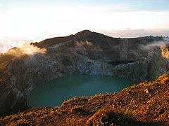
The most famous tourist attraction in Flores is the 1,639-metre-high (5,377-foot) Kelimutu volcano, containing three colored lakes, located in the district of Ende close to the town of Moni, although there is also the Inierie volcano near Bajawa. These crater lakes are in the caldera of a volcano, and fed by a volcanic gas source, resulting in highly acidic water. The colored lakes change colors on an irregular basis, depending on the oxidation state of the lake[67] from bright red to green and blue.
There are snorkeling and diving locations along the north coast of Flores, most notably Maumere and Riung. However, due to the destructive practice of local fishermen using bombs to fish, and locals selling shells to tourists, combined with the after-effects of a devastating tsunami in 1992, the reefs have slowly been destroyed.
Labuan Bajo, located on the western tip is often used by tourists as a base to visit Komodo and Rinca islands. Labuan Bajo also attracts scuba divers, as whale sharks inhabit the waters around Labuan Bajo.
The Luba and Bena villages include traditional houses in Flores. Bena is also noted for its Stone Age megaliths.
Larantuka, on the isle's eastern end, is known for its Holy Week festivals.
In recent years, local tourist firms around Kelimutu have begun promoting cycling tours around Flores, some of which take up to five or six days depending on the particular program.[68]
Economy[edit]
In addition to tourism, the main economic activities on Flores are agriculture, fishing and seaweed production. The primary food crops being grown on Flores are rice, maize, sweet potato and cassava, while the main cash crops are coffee, coconut, candle nut and cashew.[69] Flores is one of the newest origins for Indonesian coffee. Previously, most Arabica coffee (Coffea arabica) from Flores was blended with other origins. Now, demand is growing for this coffee because of its heavy body and sweet chocolate, floral and woody notes.[70]
In the 1980s, cotton crops have been encouraged to generate income for the poorer subsistence farmers.[71] It is planted in low-lying areas of the island.[48]
Jackfruit, which occurs throughout the Indonesian archipelago - and elsewhere -, is specifically cultivated in Manggarai and Sikka regencies, and probably in every other regency.[54]
Gallery[edit]
-
 The Lesser Sunda Islands with Flores in the upper right
 -
-
 Ruins of a Portuguese fort, dating from the 16th century near Ende.
 -
 An ancient Ngada megalith
 -
 Dancers in Watublapi
 -
 Villager with a headdress and chest ornamentation


Transport[edit]
There are at least six airports in Flores distributed along the island, ordered from west to east:
- Komodo Airport in Labuan Bajo
- Frans Sales Lega Airport or Ruteng airport
- Pahdamaleda Airport or Bajawa airport
- Turelelo Soa Airport in Bajawa
- H. Hasan Aroeboesman Airport or Ende airport
- Frans Xavier Seda Airport or Maumere airport
- Gewayantana Airport close to Larantuka city.
See also[edit]
- Dutch Empire
- Flores (Azores)
- Homo floresiensis
- Kingdom of Larantuka
- Manggarai people
- Maunura
- Nage tribe
- Portuguese Empire
- Simon Milward
- Theodorus Verhoeven
Notes[edit]
- ^ Maasin, one of the oldest towns in Southern Leyte (Philippines), was also called Nipa.[4]
- ^ Webb recalls the Shimabara rebellion that took place near Nagasaki in 1637 and 1638, when 40,000 Catholics entrenched themselves into an old castle on the Shimabara peninsula and held out against 120,000 Japanese soldiers for about four months; they were all put to death after they had surrendered. According to Webb, the Japanese did not want a historical repeat of it.
Nevertheless this did not stop them establishing military brothels staffed with kidnapped hundreds of young Indonesian women for their troops on the island, and treating the rest of the population and the prisoners of war as badly as they did elsewhere. See International Military Tribunal for the Far East.[23] - ^ "Ana wa" is also the word for "animal", but this is not related to the clan's name.[45]
- ^ Some tribe names are related to particular traditions and beliefs, for example the Sodha or Naka Sodha people: sodha is "a kind of song, singing", and naka is "to steal"; this refers to a ritual task whereby a designated man should "steal" a portion of cooked meat and rice before it is served at feasts, an act thought to ensure that the supply will be sufficient.[46]
- ^ Turmeric: wuné in Ngadha language.[50]
- ^ a b c Iwangeté or Iwang Geté is a small region in Sikka regency, that encompasses the villages of Watublapi (Hewokloang district),[56] Héwokloang, Kloangpopot (Doreng district),[57][58] Hale (Mapitara district), Hebingare,[59] and Doka (Bola district[55]).[54] Krowe is another name for this area, although neither names are quite accurate.[59]
- ^ Textiles from Palu’é island have narrow yellow-orange warp stripes dyed with a mixture of turmeric, betel pepper, areca nut and lime.[54]
- ^ The combination of mango bark and morinda, without oil or loba, was used in Flores and in Solor.[54]
- ^ a b c Loba Tobi or Lewotobi are common names for the district of Ilé Bura; tobi is the local Lamaholot name for the tamarind tree.[60]
- ^ The dye from kajo kuma was obtained by soaking fine wood chips in cold water without the addition of lime. Several immersions were required to produce the right shade. It is not clear whether this kajo kuma was laban or some other dyewood.[54]
- ^ In 1923, almost two-thirds of the 672 tons of aniline dyes imported into the Netherlands East Indies consisted of synthetic indigo. The remaining synthetic dyes would have been mostly purple, red, orange and yellow. Even today the number of homogeneous green dyes and pigments remains significantly less than that of any other major colour.[62]
- ^ Other areas that have retained a degree of their former textile culture are Lembata, Savu and East Sumba.[62]
- ^ Other regions that are in the process of losing or have already lost their textile culture are Bali, Sumbawa, Solor, Adonara, Alor, Roti and West Sumba.[62]
- ^ In the Ngadha region, tradition required that youger people would wear only plain or nearly plain cloths. But advancing in age was not sufficient to be allowed more prestigious, adorned cloths; one also had to go through various levels of initiation and arrange for great feasts, notably those where buffalo would be slaughtered. Only members of the upper strata of society could afford those, and ikat adorned with narrow bands of horses was a marker of that aristocratic status.[65] These days, this is no longer a traditional law but there remain in some communities the sense that only people of high social standing should wear these prestigious garments, even if there is a reluctance to talk about such class distinctions.[48]
- ^ The Ngadha, and the Manggarai to the west, have long had a legend about 'little people' who lived among them till as late as the 1500s. Add to this their primitive, cave-drawing-like images on Ngadha ikats ; and that the Ngadha and Keo languages are curiously 'nude' versions of Malay, as if encountering difficulties in assimilating its full complexity. For example, the Austronesian family of languages makes an abundant use of prefixes or suffixes (which form new words by adding extensions either before or after root-words, such as [per-]form or child[-hood]), whereas the Ngadha language uses no prefixes or suffixes. This has led linguist John McWhorter to speculate that maybe these two rudimentary languages came into being through contact with the 'little people' of Flores, Homo floresiensis.[48]
References[edit]
- ^ Monk, K.A.; Fretes, Y.; Reksodiharjo-Lilley, G. (1996). The Ecology of Nusa Tenggara and Maluku. Hong Kong: Periplus Editions Ltd. p. 7. ISBN 962-593-076-0.
- ^ a b c Badan Pusat Statistik, Jakarta, 28 February 2024, Provinsi Nusa Tenggara Timur Dalam Angka 2024 (Katalog-BPS 1102001.53)
- ^ Orinbao, P. Sareng (1969). Nusa nipa : nama pribumi nusa Flores (warisan purba). Ende (Flores): Nusa Indah. OCLC 689999229.
- ^ "History of Maasin city". southernleyte.gov.ph. Retrieved 10 June 2024.
- ^ "Where Do Indonesian Islands' Names Come From ?". thespicerouteend.com. Retrieved 10 June 2024.
- ^ Forth 2009a, p. 266.
- ^ Forth, Gregory (1998). Beneath the volcano : religion, cosmology and spirit classification among the Nage of eastern Indonesia. Leiden: KITLV Press. ISBN 906718120X.
- ^ "Flores surga kita > History & Flores today". travel2flores.info. Retrieved 10 June 2024.
- ^ "Flores". komodotouristic.com. Retrieved 10 June 2024.
- ^ Bento, Carlos Melo (2008), História dos Açores: Da descoberta a 1934 (in Portuguese), Ponta Delgada (Azores), Portugal: Câmara Municipal de Ponta Delgada
- ^ "Flores Island History". azores.com. Retrieved 10 June 2024.
- ^ "Flores". britannica.com. Encyclopædia Britannica. Retrieved 10 June 2024.
- ^ Baab, Karen L.; McNulty, Kieran P.; Harvati, Katerina (2013). "Homo floresiensis Contextualized: A Geometric Morphometric Comparative Analysis of Fossil and Pathological Human Samples". PLOS ONE. 8 (7): e69119. Bibcode:2013PLoSO...869119B. doi:10.1371/journal.pone.0069119. PMC 3707875. PMID 23874886.
- ^ a b c van den Bergh, Gerrit D.; Alloway, Brent V.; Storey, Michael; Setiawan, Ruly; Yurnaldi, Dida; Kurniawan, Iwan; Moore, Mark W.; Jatmiko; Brumm, Adam; Flude, Stephanie; Sutikna, Thomas; Setiyabudi, Erick; Prasetyo, Unggul W.; Puspaningrum, Mika R.; Yoga, Ifan (October 2022). "An integrative geochronological framework for the Pleistocene So'a basin (Flores, Indonesia), and its implications for faunal turnover and hominin arrival". Quaternary Science Reviews. 294: 107721. Bibcode:2022QSRv..29407721V. doi:10.1016/j.quascirev.2022.107721. hdl:10072/418777. S2CID 252290750.
- ^ Brown, P.; et al. (27 October 2004). "A new small-bodied hominin from the Late Pleistocene of Flores, Indonesia" (PDF). Nature. 431 (7012): 1055–1061. Bibcode:2004Natur.431.1055B. doi:10.1038/nature02999. PMID 15514638. S2CID 26441.
- ^ Morwood, M. J.; et al. (13 October 2005). "Further evidence for small-bodied hominins from the Late Pleistocene of Flores, Indonesia". Nature. 437 (7061): 1012–1017. Bibcode:2005Natur.437.1012M. doi:10.1038/nature04022. PMID 16229067. S2CID 4302539.
- ^ Argue, Debbie; Groves, Colin P. (21 April 2017). "The affinities of Homo floresiensis based on phylogenetic analyses of cranial, dental, and postcranial characters". Journal of Human Evolution. 107: 107–133. doi:10.1016/j.jhevol.2017.02.006. PMID 28438318.
- ^ Sutikna, Thomas; Tocheri, Matthew W.; Morwood, Michael J.; et al. (2016). "Revised stratigraphy and chronology for Homo floresiensis at Liang Bua in Indonesia". Nature. 532 (7599): 366–369. Bibcode:2016Natur.532..366S. doi:10.1038/nature17179. hdl:1885/109256. PMID 27027286. S2CID 4469009.
- ^ a b Fox, James J. (2003). "Tracing the path, recounting the past: historical perspectives on Timor". In Fox, James J.; Soares, Dionisio Babo (eds.). Out of the Ashes: Destruction and Reconstruction of East Timor. ANU E Press. doi:10.22459/oa.11.2003.01. ISBN 978-0-9751229-1-4.
- ^ Webb, Paul (March 1986). ""Too many to ignore...": Flores under the Japanese occupation 1942-1945". Philippine Quarterly of Culture and Society. 14 (1): 54–70.
- ^ "Flores Island (Pulau Flores), East Nusa Tenggara Province, Indonesia". pacificwrecks.com. Retrieved 7 June 2024.
- ^ Webb 1986, cited in "The influence of Catholicism on Flores island during WWII". kajomag.com. Retrieved 7 June 2024.
- ^ "The influence of Catholicism on Flores island during WWII". kajomag.com. Retrieved 7 June 2024.
- ^ "Deadly trouble for surf pioneer in Indonesia's new paradise". The Australian. 28 January 2017. Retrieved 17 October 2018.
- ^ Manggarai Barat District includes islands like Komodo and Rinca to the west of Flores
- ^ Flores Timur District includes islands like Adonara and Solor to the east of Flores, for which the figures are excluded.
- ^ Biro Pusat Statistik, Jakarta, 2011.
- ^ Badan Pusat Statistik, Jakarta, 2021.
- ^ "[New Method] Human Development Index by Regency/City 2020-2022" (in Indonesian). Statistics Indonesia. 2022. Retrieved 13 February 2023.
- ^ Ariefiandy, Achmad; Purwandana, Deni; Azmi, Muhammad; Nasu, Sanggar Abdil; Mardani, Juna; Ciofi, Claudio; Jessop, Tim S. (February 2021). "Human activities associated with reduced Komodo dragon habitat use and range loss on Flores". Biodiversity and Conservation. 30 (2): 461–479. Bibcode:2021BiCon..30..461A. doi:10.1007/s10531-020-02100-8. ISSN 0960-3115. S2CID 254279437.
- ^ Veatch, E. Grace; Tocheri, Matthew W.; Sutikna, Thomas; McGrath, Kate; Wahyu Saptomo, E.; Jatmiko; Helgen, Kristofer M. (May 2019). "Temporal shifts in the distribution of murine rodent body size classes at Liang Bua (Flores, Indonesia) reveal new insights into the paleoecology of Homo floresiensis and associated fauna". Journal of Human Evolution. 130: 45–60. doi:10.1016/j.jhevol.2019.02.002. hdl:2440/121139. PMID 31010543. S2CID 91562355.
- ^ Meijer, Hanneke J.M.; Tocheri, Matthew W.; Due, Rokus Awe; et al. (2015). "Continental-style avian extinctions on an oceanic island" (PDF). Palaeogeography, Palaeoclimatology, Palaeoecology. 429: 163–170. Bibcode:2015PPP...429..163M. doi:10.1016/j.palaeo.2015.03.041. Archived (PDF) from the original on 15 October 2018 – via repository.si.edu.
- ^ Xiaodong Yang; Satish C Singh; Anand Tripathi (25 February 2020). "Did the Flores backarc thrust rupture offshore during the 2018 Lombok earthquake sequence in Indonesia?". Geophysical Journal International. Retrieved 12 February 2024.
- ^ Djawanai, Stephanus (1983). Ngadha text tradition: the collective mind of the Ngadha people, Flores (Materials in languages of Indonesia, No.20). Pacific Linguistics, Series D (Special communications), No. 55. Australian National University. p. 2.
- ^ Peter ten Hoopen. "Ikat from Ngadha, Indonesia". ikat.us. Online Museum of Indonesian ikat textiles, curator: Dr Peter Ten Hoopen. Retrieved 8 June 2024.
- ^ Forth, Gregory (2009b). "Human beings and other people: Classification of human groups and categories among the Nage of Flores (eastern Indonesia)". Bijdragen tot de Taal-, Land- en Volkenkunde. 165 (4): 493–514. Retrieved 10 June 2024.
- ^ Barnes 1996, see Appendix I.
- ^ Steenbrink (2013)
- ^ Dagur, Ryan (28 May 2019). "Indonesia inaugurates first Catholic university in Flores". La Croix International.
- ^ Lévi-Strauss, Claude (1962). Le totémisme aujourd'hui. Paris: Presses Universitaires de France. Cited in Forth 2009a, p. 263.
- ^ Jones, Robert Alun (2005). The secret of the totem: Religion and society from McLennan to Freud. New York: Columbia University Press. ISBN 0 231 13438 X. Cited in Forth 2009a, p. 263.
- ^ a b Forth, Gregory (2009a). "Tree Totems and the Tamarind People: Implications of Clan Plant Taboos in Central Flores". Oceania. 79 (3): 263-279 (see p. 264). Retrieved 8 June 2024.
- ^ Forth 2009a, p. 263.
- ^ a b Forth 2009a, p. 264.
- ^ a b Forth 2009a, p. 267.
- ^ a b Forth 2009a, p. 268.
- ^ Arndt, Paul (1954). Gesellschaftliche Verhältnisse der Ngadha. Studia Instituti Anthropos 8. Wien-Mödling: Missionsdruckerei St. Gabriel. Cited in Forth 2009a, p. 265.
This is not the archaeologist and art dealer Paul Arndt (1865–1937). The author here was a missionary-ethnologist who lived among the Ngadha people from 1923 until his death in 1962. See Peter ten Hoopen. "Ikat from Ngadha, Indonesia". ikat.us. Online Museum of Indonesian ikat textiles, curator: Dr Peter Ten Hoopen. Retrieved 8 June 2024. - ^ a b c d e f g h i Peter ten Hoopen. "Ikat from Ngadha, Indonesia". ikat.us. Online Museum of Indonesian ikat textiles, curator: Dr Peter Ten Hoopen. Retrieved 8 June 2024.
- ^ a b Hamilton 1994.
- ^ Kikusawa, Ritsuko; Reid, Lawrence A. (January 2007). "25. Proto who utilized turmeric, and how?". In Siegel, Jeff; Lynch, John; Eades, Diana (eds.). Language Description, History and Development: Linguistic indulgence in memory of Terry Crowley (PDF). Creole Language Library 30. pp. 341–354 (see p. 343).
- ^ a b c Barnes 1989, p. 15.
- ^ a b Barnes 1989, p. 28.
- ^ a b c d Barnes, Ruth (1989). Ikat Textiles of Lamalera: A Study of an Eastern Indonesian Weaving Tradition (Studies in South Asian culture, vol. XIV). E.J. Brill. p. 31. ISBN 90 04 08753 2. ISSN 0169-9865.
- ^ a b c d e f g h i j k l "Yellow dyes". asiantextilestudies.com. Retrieved 8 June 2024.
- ^ a b "Doka (Bola district), map". google.com/maps.
- ^ "Watublapi (Hewokloang district), map, with Héwokloang to the west". google.com/maps.
- ^ "Klo'angpopot, Doreng district, Sikka regency". m.nomor.net. Retrieved 9 June 2024.
- ^ "Kloangpopot (Doreng district), map". google.com/maps.
- ^ a b "Ikat from Krowe, Indonesia". ikat.us. Pusaka Collection, Online Museum of Indonesian ikat textiles. Retrieved 9 June 2024.
- ^ a b "Lewotobi textiles". asiantextilestudies.com. Retrieved 9 June 2024.
- ^ Setyowati, Rini; Sudarsono; Setyowati, E. P (2014). "The effect of water-soluble stem extract "Kayu Kuning" (Arcangelisia flava L. Merr) on the growth inhibition of Candida albicans ATCC 10231 and Trichophyton mentagrophytes in vitro". Biology, Medicine, & Natural Product Chemistry. 3 (1): 15–19. ISSN 2089-6514. Retrieved 9 June 2024.
- ^ a b c d e f g h i j k "Green dyes". asiantextilestudies.com. 2016. Retrieved 8 June 2024.
- ^ Barnes, Robert Harrison (1996). Sea Hunters of Indonesia: Fishers and Weavers of Lamalera. Oxford: Clarendon Press. p. 368.
- ^ "Ikat from Krowe, Indonesia". ikat.us. Pusaka Collection, Online Museum of Indonesian ikat textiles. Retrieved 9 June 2024.
- ^ Hamilton (1994), cited in Hoopen & , ikat.us.
- ^ "Jerebuu village and district, map". google.fr/maps (scroll back to see the limits of Jerebuu district).
- ^ Pasternack. Keli Mutu Volcanic Lakes Archived 2 February 2017 at the Wayback Machine, University of California Davis.
- ^ Makur, Markus (13 March 2016). "Bicycle tours of Kelimutu boost local economy". The Jakarta Post.
- ^ East Nusa Tenggara Archived 10 September 2008 at the Wayback Machine, Indonesian Chamber of Commerce and Industry. Retrieved 8 August 2008.
- ^ Arabica Producing Regions of Indonesia, Specialty Coffee Association of Indonesia. Retrieved 8 August 2008.
- ^ Keefer, G.D.; Ladewig, J.; Diarini, P. (1989). "Cotton yield predictions for Lombok and Flores - Indonesia" (PDF). agronomyaustraliaproceedings.org. Australian Agronomy Conference (1989). Retrieved 8 June 2024.
Bibliography[edit]
- Hamilton, Roy W. (1994). Gift of the Cotton Maiden: Textiles of Flores and the Solor Islands. Los Angeles: Fowler Museum of Cultural History, UCLA. ISBN 978-0930741389.
- L, Klemen (1999–2000). "Forgotten Campaign: The Dutch East Indies Campaign 1941–1942". Archived from the original on 26 July 2011.
- Steenbrink, Karel (2013). "Dutch Colonial Containment of Islam in Manggarai, West-Flores, in Favour of Catholicism, 1907–1942". Bijdragen tot de Taal-, Land- en Volkenkunde. 169 (1): 104–128. doi:10.1163/22134379-12340024.
External links[edit]
 Media related to Flores, Indonesia at Wikimedia Commons
- . Encyclopædia Britannica. Vol. IX (9th ed.). 1879. p. 337.
- Flores & Komodo – History Archived 24 March 2010 at the Wayback Machine
| International | |
|---|---|
| National | |